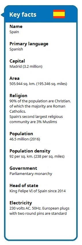
“Costa Del” Spain boasts a coastline of 4.964 kilometres (3.085 miles) and comes in seventh place of European countries with most coastline.
Known for some of the best beaches in Europe – Costa Del Sol, Costa Blanca, Costa Dorada, Costa Brava, Mallorca and Ibiza – Spain is more than beaches, summer and sun. The diversity in the country’s many regions, from Basque Country in the north to Andalusia in the south and from Galicia in the west to Catalonia in the east, makes Spain rich in culture, food and history.
Weather and Climate
Best time to visit Spain is from April to November, but the mild climate ensures, that you can visit Spain all year round.
Summer, spring, autumn and winter seasons are unknown in Spain. Here, you have a warm period, a cool period and a cold period. The climatic conditions in Spain are generally divided into three main groups with Atlantic climate of the coastal areas in the northwest, Mediterranean climate along the coast to the east and south and continental climate on the central plateau.
In northern Spain, the many deciduous trees start their defoliation in November, but before that, the leaves change colour in late October and December is the beginning of the cold period. In March, the weather goes from cold to cool and finally, the warm period begins in May. Like so many other large countries, there is of course a big difference between north and south.
In southern of Spain, there is a warm and a cool period with very little precipitation. Most precipitation comes in November, December and January. The average temperature in these three months is about 18 ℃ (64.4 ℉) which makes Costa Del Sol a popular destination for pensioners and holiday-makers.
In central Spain, it can become very hot in June, July and August and very cold from November to March. In return, there will be very little precipitation during these months.
Geography
Spain, together with Portugal, form the Iberian Peninsula.
In the middle of the Iberian Peninsula, La Meseta – the approximately 210.000 sq. Km. (81.081 sq. Miles) large plateau – rises to an average height of about 600 metres (1.968 ft.) above sea level. The plateau stretches west into Portugal and includes the Spanish regions of Castilla y León, Castilla-La Mancha, Madrid and Extremadura. Mountains surround the plateau with rivers in the middle.
La Mesetas northern part is defined by the Cantabrian Mountains and to the east by the Iberian mountains. The river Duero flows in La Mesetas northern part and continues into Portugal and into the Atlantic Ocean. La Mesetas southern part is bounded by the Sierra Morena, and to the east flows rivers Tajo and Guadiana towards the Atlantic Ocean.
The Iberian mountain range separate La Meseta from Valencia and the Mediterranean.
In north-west of Spain, the Cantabrian Mountains rise with the highest point being Torre de Cerredo at 2.648 metres (8.687 ft.) in the mountain range Picos de Europa. North of the Cantabrian Mountains – in Asturias, Cantabria and the Basque country – the landscape drops abruptly down to the coast of the Bay of Biscay. To the west, the Galician coastline is dominated by steep cliffs and deep valleys.
In the northeast, the Pyrenees mountain range borders Spain against the France and Andorra. In this area, the second largest mountain of Spain, the Pico del Aneto, towers with its 3.404 metres (11.167 ft.). In the south of the Iberian mountain range lies the great floodplain Ebro valley. The Ebro river is very water-rich and its tributaries irrigate about 17% of Spain’s total area.
South of the flood plain, the Sierra Nevada mountain range rises. Here, the Iberian Peninsula’s highest peak is found; Mulhacén at 3.480 metres (11.417 ft.).
5 things Spain is known for, outside Spain
- Antoni Gaudi (Architect, 1852-1926)
- Pablo Picasso (Surrealist artist and painter, 1881-1973)
- Corrida De Toros (Bullfighting)
- Sherry (Fortified wine from the Cádiz region)
- Siesta (Midday meal and a short nap, somewhere between 1pm and 5pm)
Learn more
